WAMS

Walking Access Mapping System: New Zealand for all to see

In 2010 the New Zealand Walking Access Commission worked closely with geospatial solutions developers Geographic Business Solutions (GBS) to create the Walking Access Mapping System (WAMS) – an interactive web-accessed map that shows Kiwis exactly where they have access. Recently, an enhanced version of the mapping system went live. The new version allows approved partners to add useful information to the map, such as hiking trails, fishing spots, gateways, mountain biking trails, campsites, lookout points and much more.

Background

Established in 2008, the New Zealand Walking Access Commission is a Crown entity that exists to enhance public access to New Zealand’s magnificent outdoors. More than a third of the country is available for public access, but until recently finding out exactly where you can walk wasn’t easy. The Commission was created by the Walking Access Act 2008, with the purpose of providing the New Zealand public with ‘free, certain, enduring and practical’ walking access to the outdoors.

One of the Commission’s first tasks was to develop an online map that lets any one – domestic or international – see where they can walk in New Zealand. Developed by geospatial software specialists GBS and known as the Walking Access Mapping System, the first version of the tool went live in test mode in December 2010, then officially launched in July 2011. Although it hasn’t been promoted widely, the mapping system had more than 90,000 visitors in the financial year ending July 2012. That’s an average of 250 visits a day. The tool works with data supplied by Terralink International Ltd, a major provider of land and property data.

When it was launched, the Walking Access Mapping System was unique in the world. It combined cadastral (public record) data with topographical data and aerial imaging on one website-hosted map, which meant mixing and matching public and private information. Users could see at a glance if land was public or private.

“As you’d expect, the Walking Access Mapping System is being used by recreational groups and the public generally. But it also has commercial and government users – property and forestry businesses, for example. They can use it to calculate land area, because the data in the mapping system is very accurate. New Zealand has a Torrens-based land data system, which is also used in the Philippines, Thailand and Malaysia, Australian states, some Canadian Provinces, some states in the United States and other places where the British flag once flew”, said New Zealand Walking Access Commission Chief Executive Mark Neeson.

In early 2012, six months after the launch of the Walking Access Mapping System, the Commission conducted a survey of users to gauge the success of the project. An extremely convincing 97% of people said it was useful, and the same percentage said they’d recommend it to friends and colleagues. At the same time, they made it clear that they wanted more.

The Challenge

For GBS, the greatest challenge was making certain the Commission received what it needed for the budget allocated to the project. Fortunately, the Agile SCRUM methodology that GBS use to develop software ensures the best-possible result for the money. Harley Prowse of GBS, explains:

“With Agile SCRUM, projects are split into sprints. Each sprint is a short cycle of development that’s focused on delivering a usable version of the software. Successive sprints learn from the previous sprints, until you get the final version. There are no surprises and issues are revealed early on, when there’s still
plenty of time to make changes.”

Neeson found the Agile SCRUM methodology reassuring. “When you’re working with a fixed budget, you can’t afford to have problems crop up at the last minute. The Agile process ensures an ongoing conversation between the client and the contractor, which is essential for a successful outcome. GBS has been a very good partner for us. We have a high level of trust in their ability to do the work and deliver.”

Key Benefitis of the Walking Access Mapping System

  • Users can immediately see public-access land anywhere in New Zealand
  • Information partners, such as recreational group and Department of Conservation, can add information and images to the mapping system
  • Depending on the information that has been added by partners, users can see where they’re allowed to cycle, walk, fish, hike, bike, kayak, camp, boat, hunt, swim, ski, 4WD, see sights, climb, ride horses and more
  • Users can use the draw functions to create personalised maps with way points and text comments, and they can export GPS information to mobile devices
  • When a mapping system user has a question or encounters an issue concerning public access, they can use the site to notify the New Zealand Walking Access Commission.

The GBS solution

Harley Prowse explains the various components that make up the Walking Access Mapping System.

“For version one, we put Esri ArcGIS Server under the hood – this serves the maps and provides the clever geospatial functionality. Then there is a SQL Server data base in behind the scenes, while at the front end you’re seeing and Adobe Flash application. For the new version, we’re using the same components, but with updated versions of Esri ArcGIS and Flash. We’re also launching a JavaScript-based mobile version, so the Walking Access Mapping System will be smartphone-friendly – great when you’re actually in the outdoors.”

The biggest difference between the old and the new is the ability for approved partners to contribute images and information. Ric Cullinane, Operations Manager at the Commission, is excited by the prospect. “We’re currently negotiating with information providers, such as the Department of Conservation (DOC) and recreational groups, to add significantly more detail to the mapping system. Approved partners are able to upload data onto the site, creating ‘recreational points of interest’. And it remains their data, which means management and updates are their responsibility.”

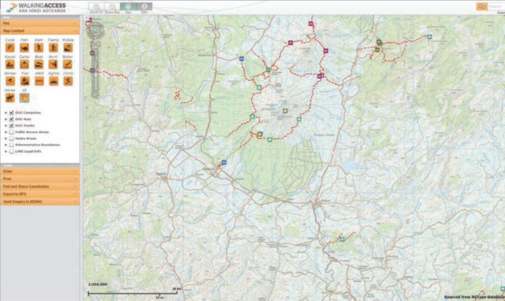
So if you’re contemplating a fishing expedition on the Rangitikei River, the Walking Access Mapping System has the potential to pinpoint all the things you need – campsites, huts, fishing spots, cycling tracks, walking tracks, historic places of interest and more. If you’re within mobile range, you can access all this data through your smartphone. The look and feel of the mapping system has also been upgraded with the new version. The map occupies more of the screen and the side bar can slide away with a click.

There’s also a handy set of drawing tools, so that you can plan an excursion complete with way points and text comments. Plus users can export GPS information into any GBS-enabled device, to guide them during their expedition. From a tourism perspective, both domestic and international, the Walking Access Mapping System broadens the horizon for adventure. The mapping system also gives users the facility to make enquiries direct to the Commission about access or report problems.

Users can draw lines on the map, annotate, attach photos and even copy newspaper reports, then send them all to us. We’ll take up the case and keep them informed”, said Cullinane.

GBS-case-studies-logos-Esri-Partner-Network-image

FROM OUR CLIENT

The first version of the mapping system received a great deal of positive feedback from its users. There were no criticisms, however, respondents indicated they wanted more functionality, more information and more mobile friendliness

Contact us to find out more