Cityworks

Manage your work.  Anywhere. Anytime.


– GIS Centric

Built exclusively on Esri® ArcGIS®, Cityworks helps you fully leverage your authoritative GIS data and provides a total solution to improve your agency’s operational effectiveness.

– Open Architecture

Cityworks is built on open standards, giving you complete access to your data in an open architecture that easily integrates with existing business systems.

– Flexible

Easily create templates to manage common asset management activities. Or, think outside the box and modify them for virtually any business process where workflow, tracking, and GIS are needed.
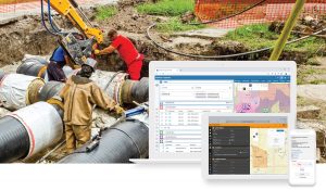
– Mobile

Empower your field crew to interact directly with GIS assets by collecting information, reporting observations, uploading pictures, completing outstanding tasks, and using visual map tools to streamline workflows.

– Public Engagement

Cityworks data and ArcGIS tools empower your customers to provide input, remain informed, and monitor progress

– Location Intelligence

GIS maps offer a superior platform for interpreting data and supporting location intelligence. Cityworks and ArcGIS help local governments and utilities do more with less when managing capital infrastructure and regulations.

Cityworks

Leverage your investment in GIS without redundancy data synchronisation, or special integration.

Download the brochure

For more information visit www.cityworks.com

More GBS products

Edit+

Edit+ An ArcGIS Web AppBuilder widget that brings advanced editing, including topology editing and error checking, to your browser. Bring the power of desktop GIS editing to your browser to make it easier for data owners to edit and manage their own spatial data. Edit+ is an ArcGIS Web AppBuilder widget that brings advanced editing, [...]

CHPS

CHPS In collaboration with Scion and a number of leading forestry management companies, GBS has developed CHPS (Cable Harvest Planning Solution), a dedicated forestry planning tool for analysing terrain where cable haulers are used to extract logs. It has been praised for its intuitive, seamless integration to ArcGIS for Desktop (ArcMap). CHPS is only available [...]

ART

ART -  Automated Reporting Tool Do you want to speed up and simplify your LIM processing? Just select a property and go! The ART application is an easy to use Esri geo-processing system and REST web service. It automatically produces LIM Maps and documents and can be easily integrated into your existing systems. Read More More [...]